
Places to Watch First Edition: Five Indicated Illegal Logging Area in Indonesia
This is the first of the Places to Watch series on illegal logging in Indonesia. These articles will periodically identify five places in Indonesia suffering from illegal logging. The compiled list serves as a reference for stakeholders on the supervision and law enforcement of illegal logging in Indonesia.
Illegal logging eradication has been one of the nine priorities of the Joko Widodo administration known as Nawacita as well as a strategic goal of the Ministry of Environment and Forestry in their 2015-2019 Strategic Plan (Renstra).
Based on Law No. 18 of 2013 on the Prevention and Eradication of Deforestation, illegal logging is defined as illegal timber supply chain activities, which include logging, processing, transporting, storing, marketing, sales, and purchase as well as illegal timber utilization. Illegal logging also includes logging within a forest area without a valid permit or in a manner not in accordance with the permit requirements.
An interactive map of the 5 Places to Watch: Indications of Illegal Logging in Indonesia can be accessed through bit.ly/PlacesToWatch
1. Clustering of GLAD Alert pixels in a 25-km2 grid;
2. Calculating concern score: multiplying the percentage of Forest Area with no logging permit by the number of GLAD Alerts pixels in each grid;
3. The 5 Places to Watch were selected through statistical concern score analysis. The method generated the 5 Places to Watch in Indonesia where logging is most rampant during the January–March 2018 period. We then verified through the high definition and publicly available satellite images in the last 3–6 months to view field conditions by observing patterns of human activities such as plantations, agriculture and roads.
The cases of illegal logging in this edition are identified based on the first criterion, specifically logging within a forest area without a valid permit during the January-March 2018 period. The second criterion is currently not used due to limited access to data concerning companies’ work permit.
#1 An indication of Illegal Logging of 70 Hectares of Production Forest Area for Mining Area Expansion in Gunung Mas and Pulang Pisau Regencies, Central Kalimantan
Logging has been identified in a production forest area measuring 70 hectares or 65 times the size of a football field. Indications show that the clearing was done as a part of an expansion of a mining area in Sepang Simin Sub-District, Gunung Mas District, and Banama Tingang Sub-District, Pulang Pisau District, Central Kalimantan. Deforestation was indicated by the conversion of forest cover into a bare soil on the borders of an existing open mining area.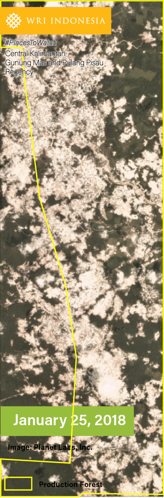
Illegal mining runs rampant in Gunung Mas and Pulang Pisau Districts, including in the previously identified sub-districts.
#2 An Indication of Illegal Logging of 58 Hectares of Forest Estate for Palm Oil Plantation Expansion in Pesisir Selatan District, West Sumatra
Indications show that illegal logging of 58 hectares of forest has taken place in Lunang, Pancung Soal and Basa Ampek Balai Tapan Sub-Districts, West Sumatra. The area is located adjacent to an existing palm oil plantation, indicating that the clearing was a part of the expansion of the plantation.
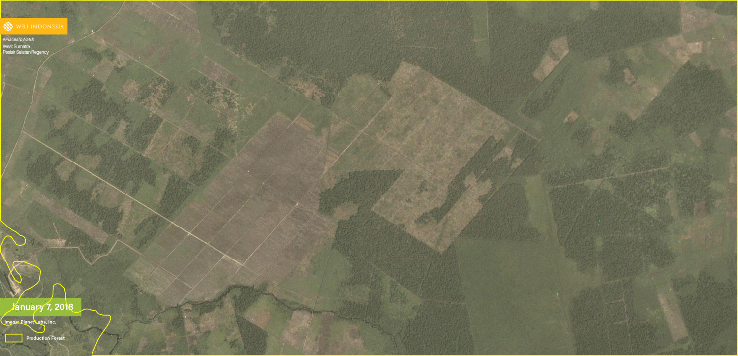 According to the Government of Pesisir Selatan District, illegal logging and forest area utilization for non-forest activities are some of the main challenges of the district’s environmental management and protection efforts.
#3 An Indication of Illegal Logging of 14 Hectares of Conservation Forest and Production Forest Areas for Agricultural Land Clearing in Monta, Dompu Regency and Hu’u Sub-Districts, Bima District, West Nusa Tenggara
Illegal logging of 14 hectares of forest areas for agricultural activity expansion is visible through satellite imagery, which shows the changes from forest area into cleared land until the cultivation of the crops .
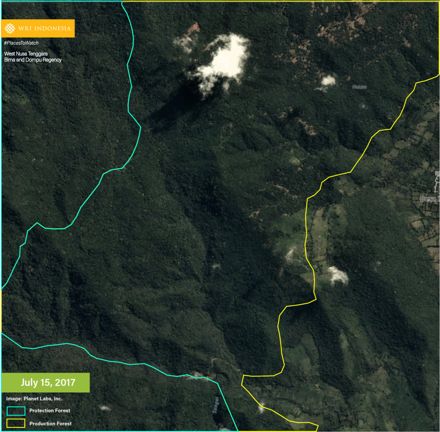 Forest clearing for farming activities is reportedly increasing in the Dompu and Bima Districts. Rampant land clearing is the alleged cause of frequent flooding in both districts, including in the Monta and Hu’u Sub-Districts.
#4 An Indication of Illegal Logging of 14 Hectares of Production Forest Area for Agricultural Land Clearing in Muko-Muko District (Bengkulu) and Kerinci District (Jambi), as well as the Kerinci Seblat National Park, Jambi (TNKS)
A pattern of deforestation for agricultural land clearing is visible through satellite imagery. The places showing sign of deforestation include Selagan Raya Sub-District (Muko-Muko District), Jangkat Sub-District (Merangin District) and Gunung Raya Sub-District (Kerinci District).
 TNKS is a national park designated as a Tropical Rainforest Heritage of Sumatra by UNESCO in 2004. But in 2011, UNESCO changed its status to World Heritage in Danger due to threats such as agricultural encroachment and illegal logging. According to data on tree cover loss in 2017 published by Global Forest Watch, the loss of primary forest within TNKS has been increasing to 7,500 hectares. Three sub-districts that indicate illegal logging activities include TNKS plots adjacent to a production forest area.
#5 An Indication of Illegal Logging of 12 Hectares of Production Forest Area for Timber Utilization Without Permit at Rokan IV Koto and Pendalian V Koto Sub-Districts, Rokan Hulu District, Riau.

High-definition imagery indicates the clearing of 12 hectares of forest without revegetation efforts during the period of December 2017-March 2018. Rokan IV Koto and Pendalian V Koto Sub-Districts are some of the indication regions.
A Rokan Hulu forest ranger stated that Rokan IV Koto and Pendalian V Koto Sub-Districts are some of the zones most vulnerable to large-scale illegal logging.
Next Steps
Despite still being indicative in nature, the Places to Watch may be used as an instrument to determine priority places for monitoring. To that end, the following steps need to be taken immediately.
1. Field Verification and Action to Prevent Illegal Logging Expansion Across the Five Indication Regions
The five indicative regions show a trend that illegal logging is not the pioneer in the area but resulted from the expansion of ongoing activities. These regions are indicated to be at risk of experiencing encroachment into the surrounding forests.
The officials authorized for forest area protection in the indicative regions must immediately conduct field verification and take immediate action to prevent further illegal logging and illegal forest utilization. Community crowdsourcing in providing on-site information may enhance the verification process. The larger the forest areas that have been cleared and utilized for non-forestry activities, the more difficult it will be to manage and restore.
2. Following verification, the response must take the socio-economic background of the local communities into consideration.
Illegal logging in the five places is closely associated with small-scale economic activities. This is why the response after verification must take into consideration the socio-economic background of the local communities. Handling mechanisms may include logical and fair conflict resolution, social forestry and law enforcement schemes. In addition to this, it is also necessary to identify perpetrators all the way up to the mastermind (intellectual player) who has reaped the ultimate benefit of illegal logging.
-
GLAD Alerts is a warning system developed by the University of Maryland to support Global Forest Watch. GLAD Alerts shows the weekly loss of forest cover in 30-m resolution pixels. One pixel represents the loss of 50% or more forest cover in an area of 0.01 hectares. ↩︎
-
Forest Area Data and Logging Permit are sourced from KLHK geoportal http://geoportal.menlhk.go.id/arcgis/rest/services/KLHK that was accessed in March 2018 ↩︎