
3 Types of Peatlands to Avoid for the Food Estate Program
The Food Estate Program to secure domestic food supplies is a National Strategic Program implemented by the government under Presidential Regulation No. 109/2020. While the program is aimed to protect national food security, a number of analyses have shown that the food estate program is ineffective and fails to address the root of the problem. The Food Estate Program in Central Kalimantan in particular is put under the spotlight as its development takes place in a failed peatland development zone (PLG) from President Soeharto’s era.
Peatland plays a significant role in climate change mitigation and adaptation. This ecosystem stores 20 times more carbon than tropical rain forest or mineral soil. Peatlands also store around 10 percent of the world’s fresh water reserve and are home to a rich biodiversity.
On the other hand, peatland is prone to disruption. Peatland is categorized as marginal lands due to its low fertility, highly acidic pH level and constant flooding in its natural state. However, it is possible for such land [to be used] for food estate.
As of the publication of this article, the government has not announced which ex-peatland development area will be used for the program. Only general information is currently available. The absence of detailed information has prevented civil communities and academicians from analyzing the risk of peatland and forest conversion. The lack of information may also hamper monitoring over land development on peatland and may lead to conflicts between the communities and parties involved in the program.
Here’s our analysis of the three peatland categories to be avoided for food estate:
1. Peatlands with a depth > 1 meter
Moderate to very deep (>1 meter) peatlands have low load bearing capacity, making it a less ideal option for agriculture. Due to its low fertility, the land relies on the mineral layer under it for plant nutrition.
On the other hand, the deeper a peatland, the more carbon it stores. A 12-meter peatland can store close to 22.3-Gt carbon, increasing the risk of carbon loss when it is converted into an agricultural land.
In short, the deeper a peatland, the less ideal it is for food crop cultivation.
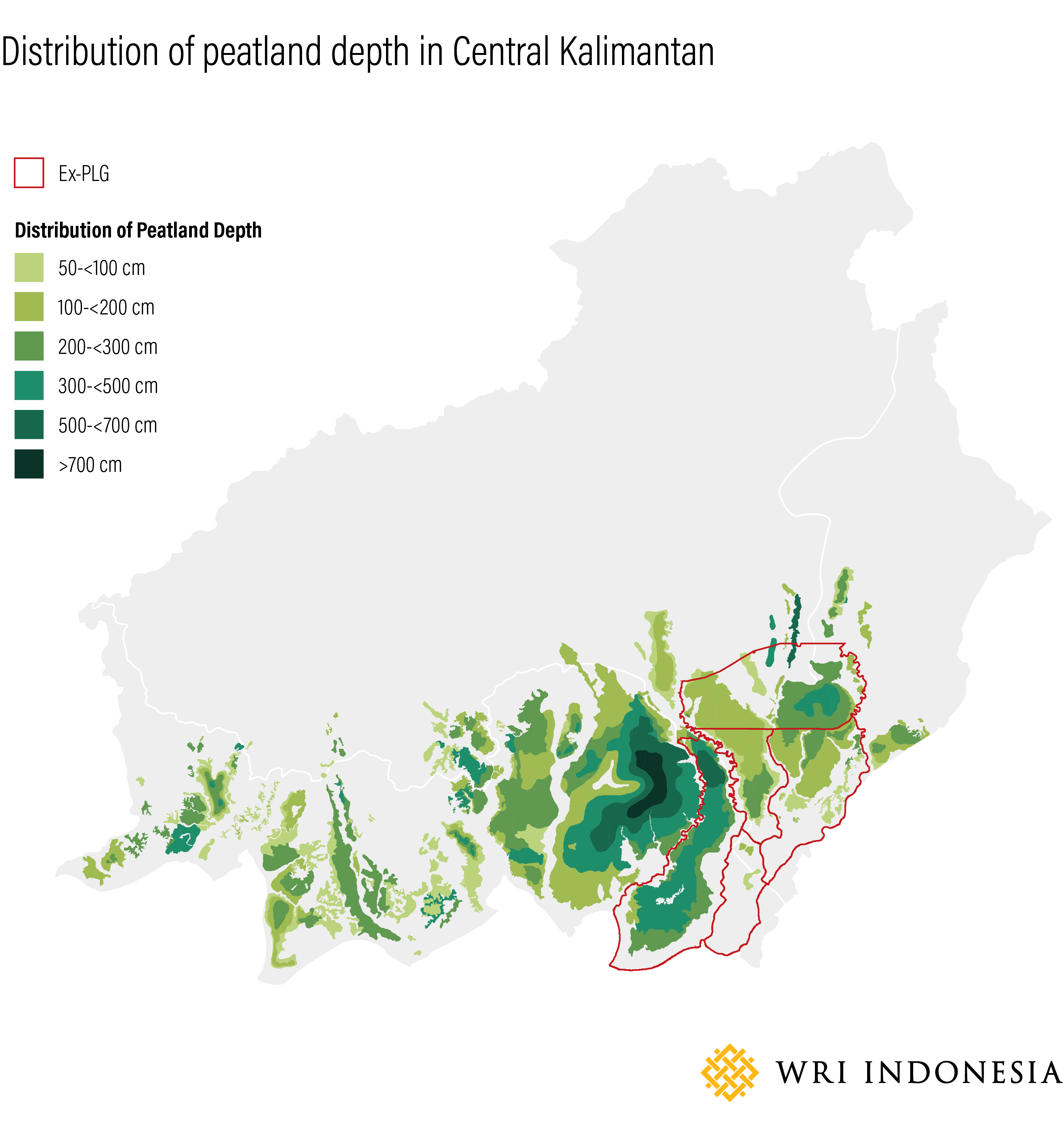
Source: Indonesian Center for Agricultural Land Resources Research and Development (BBSDLP, 2019)
2. Peatlands with (primary and secondary) forest vegetation
The vegetation of peatland forests plays a key role in maintaining the ecosystem as one of the three key components in addition to peatland soil and water. Undisturbed peatland forest vegetation will maintain the hydrological balance and ecology of the peatland.
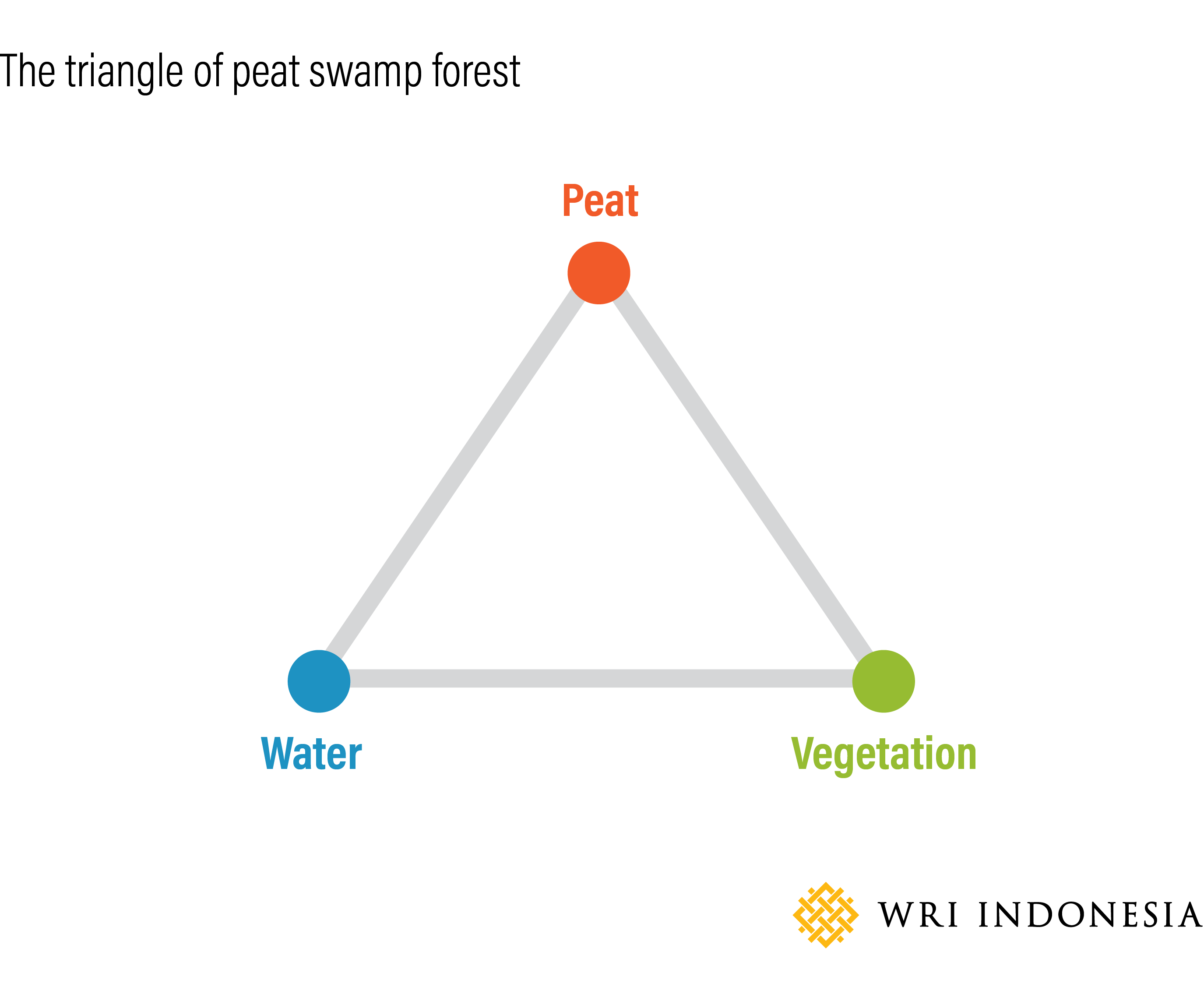
Source: Wetlands International (2018)
The use of peatlands for agriculture is usually preceded by land preparation, which is commonly done by cutting down the natural vegetation in the peatland forest and making drainage channels. This usually jumpstarts peatland degradation in the form of surface-water depletion, peat soil decomposition, greenhouse gas emission and peatland subsidence. Measured carbon emission on open peatland without vegetation reaches 62.25 ton of CO2/ha/year, the equivalent of burning more than 26,000 liters of fuel.
Natural peatland vegetation has high biomass density at around 56 to 200 tons of carbon/hectare, close to the density of a primary forest on mineral soil and 40 times more than carbon reserve on rice field. The loss of natural vegetation on peatland forest along with drainage lead to the loss of peatlands’ natural ability to store carbon and absorb water. In this condition, peatlands will dry and be prone to burning from sparks, which lead to the emission of not only carbon but also other greenhouse gases such as methane, which is 21 times more hazardous than carbon dioxide.
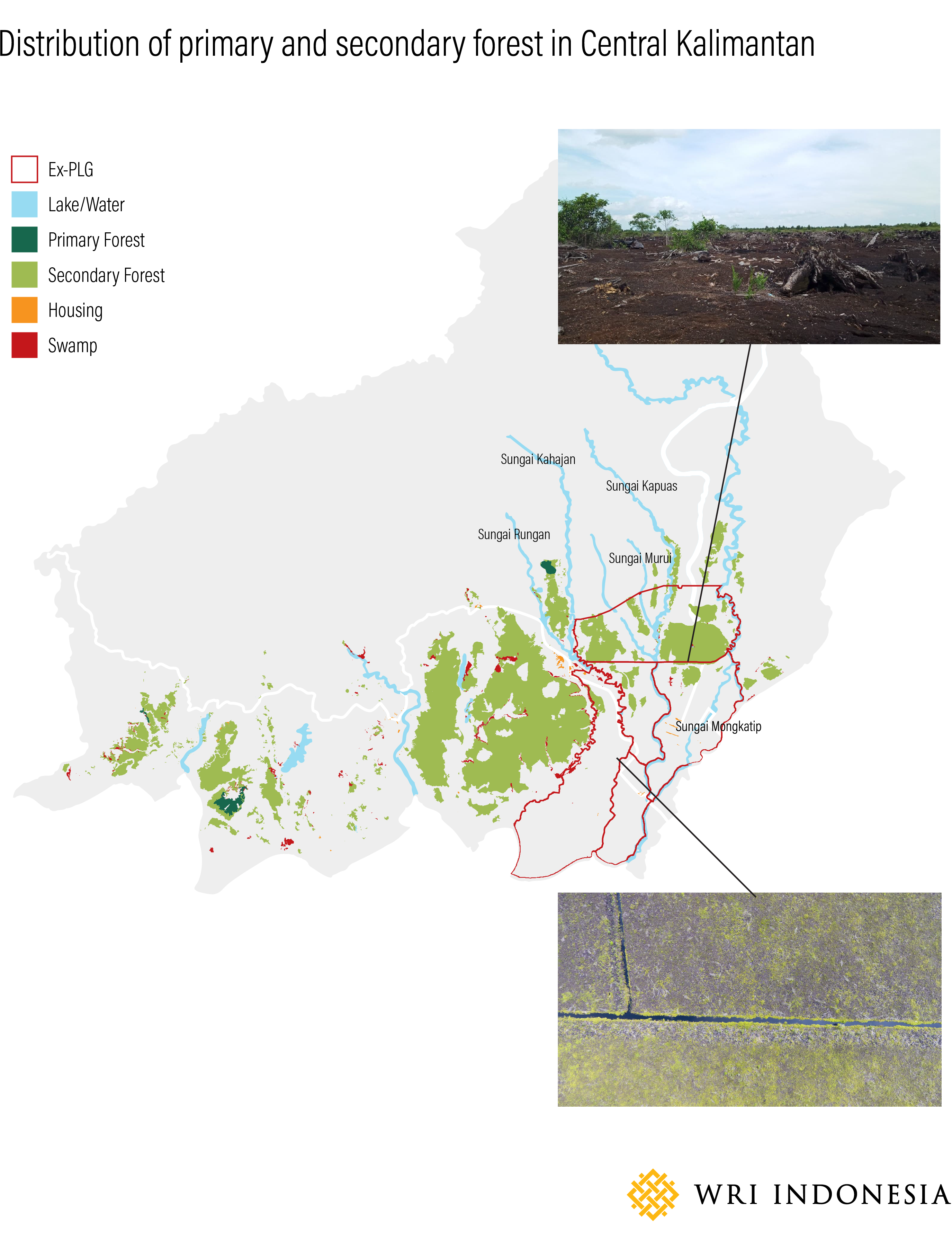
Source: Ministry of Environment and Forestry (KLHK, 2019)
3. Protection peatlands
Government Regulation (PP) No. 71/2014 jo. PP No. 57/2016 on Peatland Ecosystem Protection and Management categorizes peatland ecosystem into two functions of protection and cultivation. The protection function covers water management protection and balancing as well as carbon storage in a peatland area. When this function is disturbed, the ecosystem becomes prone to degradation, increasing the risk of fire.
Indonesian laws and regulations have not set the criteria for the conversion from peatland protection to cultivation. However, the government is required to set a protection peatland ecosystem area that makes up at least 30 percent of the entire peatland hydrological unit
(KHG)1. This means that protection peatlands within and outside of forest zones must continue to be protected.
A food estate policy that converts a forest area without consideration of its protection function is in violation of the regulation. According to the Ministry of Environment and Forestry Regulation No. 24/2020 on Forest Area Procurement for Food Estate, there are two methods of procurement, which are forest area conversion or the designation of a forest zones for food security.
However, the criteria set for the two methods do not exclude forest zones that cover protection peatlands. Therefore, there is a potential for a protection peatland to be cleared for food estate. This policy may also lead to the conversion of a protection peatland ecosystem outside of a protection forest area, including production forest areas and area of other uses (APL). Based on the analysis of WRI, there are around 883,475 hectares of protection peatland within the ex-PLG, of which 92 percent are in a conservation and protection forest, 4 percent are in a production forest and 4 percent are in an APL.

Source: Ministry of Environment and Forestry (KLHK, 2019)
No-Go Zone Map in the Ex-PLG Zone
The “no-go zone” is an indicative map of areas with high conservation value that need to be protected and avoided in the food estate program development based on analysis on the criteria for the three zones above. The no-go zone map indicates that a total of 1,091,973.67 hectares (74 percent) of the total ex-PLG area (1,473,180.4 hectares) should not be converted into an agricultural land.
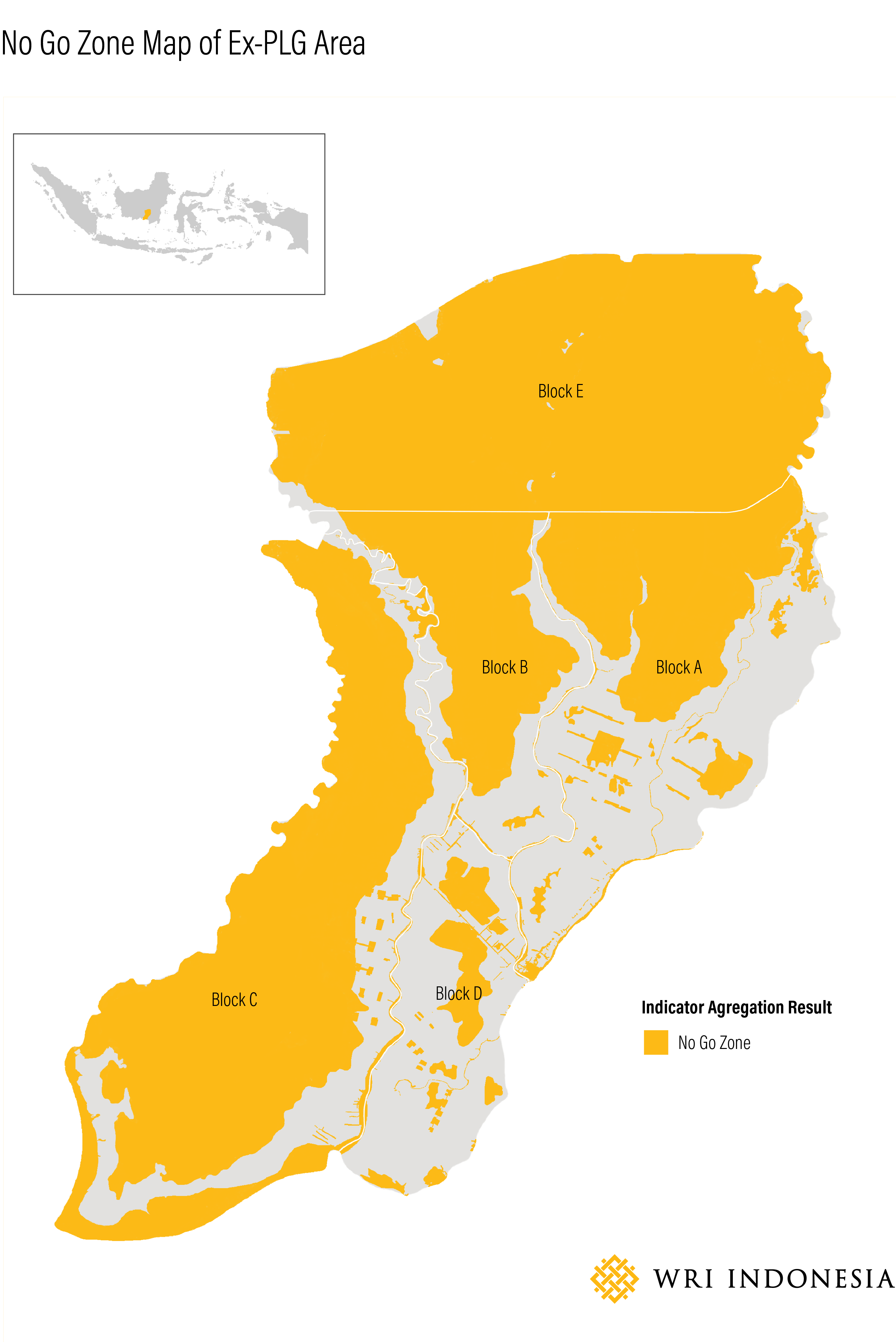
Source: Analysis by WRI Indonesia Team
Peatland protection and management should use the KHG-based approach, since this ecosystem comprises peatland components that work as one intertwined unit to maintain balance, stability and productivity. This is key in preservation efforts and the prevention of peatland ecosystem degradation.
Learning from the failures of the PLG project and their impact on environmental damage and peatland degradation acceleration, the government should be more careful in using peatlands for food estate. Peatland conversion into agricultural land without special treatment will dry peatland’s naturally wet ecosystem, increasing the risk of fire and land degradation.
Agricultural activities on peatlands must take the following into consideration:
a. Use cultivation land and previously utilized land, and refrain from converting peatlands that fall under the foregoing three criteria into agricultural lands;
b. Apply peatland friendly principles in plant cultivation practices by refraining from drying or burning peat and by avoiding environmental pollution;
c. Conduct a more comprehensive environmental impact analysis and evaluation on the peatland and the surrounding area with a focus on the ecology of the peatland hydrological landscape; and
d. Amendment to the Ministry of Environment and Forestry No. 24/2020 on the restriction of the clearing of forest area with protection peatlands and consider the biophysical criteria.
-
Peatland Hydrological Unit is a peatland ecosystem located between 2 (two) rivers, between a river and the sea and/or on a swamp. ↩︎