Making Big Ideas Happen

Resources

Tags

Life at WRI Indonesia

Women and 3D Mock-Up

  • Climate
  • forests
  • gender
  • Mapping
  • Life at WRI Indonesia
  • Climate
  • forests
  • gender
  • Mapping
  • Life at WRI Indonesia

5 Maps Show How Important Indigenous Peoples and Local Communities Are to the Environment

  • Forests & Land Use
  • Climate
  • deforestation
  • human rights
  • indigenous people
  • land rights
  • land tenure
  • Mapping
  • Forests & Land Use
  • Climate
  • deforestation
  • human rights
  • indigenous people
  • land rights
  • land tenure
  • Mapping

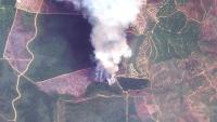
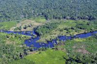
Places to Watch: 5 Forests at Risk This Month

  • deforestation
  • forests
  • Global Forest Watch (GFW)
  • Mapping
  • deforestation
  • forests
  • Global Forest Watch (GFW)
  • Mapping

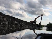
3 Ways Governments Can Prevent Fake Data on Forests

  • data
  • deforestasi
  • deforestation
  • forests
  • Indonesia
  • Mapping
  • data
  • deforestasi
  • deforestation
  • forests
  • Indonesia
  • Mapping
Insights

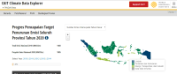
Evaluating Indonesia’s Progress on its Climate Commitments

  • climate
  • climate change
  • climate data
  • climate policy
  • data iklim
  • iklim
  • climate
  • climate change
  • climate data
  • climate policy
  • data iklim
  • iklim
Insights

Reforming Indonesia's climate readiness crucial before and after Marrakesh

  • climate
  • climate agreement
  • climate data
  • climate
  • climate agreement
  • climate data

Opposing a Contempt of State with One Map

  • forest
  • Mapping
  • forest
  • Mapping
Insights

As Indonesia’s Dry Season Looms, a New Tool Can Predict Daily Forest Fire Risk

  • agriculture
  • deforestation
  • forest
  • Indonesia
  • Indonesia forest fires
  • Mapping
  • agriculture
  • deforestation
  • forest
  • Indonesia
  • Indonesia forest fires
  • Mapping
Insights
  • climate
  • climate data
  • Indonesia

Destruction of Tropical Peatland Is an Overlooked Source of Emissions

  • agriculture
  • deforestation
  • degraded land
  • Indonesia
  • Mapping
  • maps
  • palm oil
Peat drainage canals, combined with fire, are used to make land more suitable for agriculture. Photo by Nancy Harris/Flickr
  • agriculture
  • deforestation
  • degraded land
  • Indonesia
  • Mapping
  • maps
  • palm oil

We Can Save Tigers from Extinction, with a Little Help from Satellites

  • deforestation
  • Endangered Species
  • forests
  • Mapping
  • deforestation
  • Endangered Species
  • forests
  • Mapping

Counting Trees to Save the Woods: Using Big Data to Map Deforestation

  • Climate
  • climate
  • climate change
  • climate data
  • deforestation
  • forest restoration
  • forests
  • Global Forest Watch (GFW)
  • maps
What can other big data initiatives seeking to combat climate change learn from Global Forest Watch? Photo credit: CIAT/Flickr
  • Climate
  • climate
  • climate change
  • climate data
  • deforestation
  • forest restoration
  • forests
  • Global Forest Watch (GFW)
  • maps