
What is Peat Subsidence and How Can Countries Prevent this Environmental Disaster?
Peatlands are among the most valuable ecosystems on Earth. The carbon-rich ecosystems, located near wetlands around the globe, store almost a third of the world’s terrestrial carbon, creates a great habitat for wildlife and plays an important role in water management. It also provides livelihoods for communities by supporting agricultural activities and producing natural products, such as medicinal plants or honey. Sadly, peatlands are also prone to disturbance, both from natural and human activity.
Among the biggest issues is what’s known as “peat subsidence,” a form of land subsidence, which is the downward movement of the Earth's surface due to the removal of subsurface earth materials. Land subsidence is more familiar when we talk about it happening with mineral soil. For example, land subsidence is sited as a cause of why big cities, like Jakarta in Indonesia, are sinking.
Peat subsidence triggers a number of environmental problems, including flooding, loss of land productivity and correlates strongly with carbon dioxide emissions. It’s also an issue that doesn’t receive much attention and is often perceived as a “sleeping disaster.” That is why finding ways to protect peatlands is so crucial.
Causes of Peat Subsidence
The main driver of peat subsidence is the removal of groundwater from the naturally water-logged ecosystem, mostly due to the construction of canal drainage. The use of an intensive drainage system aims to make peatlands more suitable for agricultural crops and for transportation purposes. This activity, however, leads to the decline of water table depth causing peat soil to become drier and decompose faster. As a result, the previously water-logged peat layer is exposed to oxygen, increasing microbial activities and biological oxidation of the organic deposits. The oxidation of the peat ultimately leads to large carbon losses, which triggers subsidence.
Data from drained high-latitude peatlands in European countries and the U.S. show a decrease in subsidence rate over time, from around 6 centimeters (2.36 inches) per year shortly after drainage to approximately 1 to 3 centimeters per year (0.39 to 1.18 inches) after a century. Meanwhile, cumulative subsidence reported in tropical peatlands in Southeast Asia are much higher. The rates could reach 1.5 meters (4.92 feet) over the first five years, of which 0.75 meters of subsidence (2.46 feet) occurred during the first year after drainage. The peat subsidence rate will decrease over time following drainage, and the average is reported to be around 2 to 6 centimeters per year (0.78 to 2.36 inches). One indication of peat subsidence in the field is the exposure of root systems.
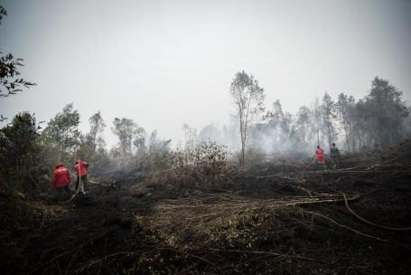
Peat subsidence is also triggered by a combination of processes, such as compaction by heavy equipment, the construction of settlements and roads, shrinkage through the contraction of organic fibers when drying and consolidation by loss of water from pores in the peat. Peat subsidence is also caused by the decomposition and compression of peat volume due to peat fires. A 2019 study by WRI Indonesia showed a peat fire in South Sumatra led to a 10-centimeter (3.93-inch) loss of peat layer. However, there are reports from other fires in Indonesia that resulted in a loss of 50 centimeters (19.69 inches).
Impacts of Peat Subsidence
Many environmental problems are triggered by peat subsidence. It increases the potential of flooding, decreases freshwater storage caused by saltwater intrusion and ruins buildings, roads and other infrastructures. Since it progressively increases flood risks in peatlands, it also causes land productivity loss and make peatlands unsuitable for cultivation. Aside from these direct impacts, peat subsidence also leads to economic losses, such as building destruction, damaged roads, land and crop productivity losses, and adaptation and mitigation costs.
Peat subsidence can also cause flooding by changing the physical characteristics of the peatlands surface. After several decades of subsidence, and if there are no preventive measures to stop or slow down the process, the affected peatlands will increasingly become relatively low-lying parts of the landscape. When this occurs, rainwater accumulates in the peatland areas, causing seasonal flooding. Furthermore, the surface level of peat layers may become lower than the high water level in nearby rivers or the sea. Consequently, over time, the surface of the peatland will become lower than the river and/or sea water level. In this stage, peatlands have reached the drainability limit, the condition when peatlands can no longer be drained by gravity and thus become permanently flooded.
The damages will worsen from the impacts of climate change, due to sea-level rise and the effects of new rainfall patterns that could increase the flood risk in the lowest-lying areas, especially peatlands near the sea. The subsiding of coastal peatland in combination with a rising sea level will substantially reduce the terrestrial area.
We’ve already seen this in places like Bengkalis Island, an island in Indonesia with about 89% of its land area consisting of peatland. Between 2014 and 2020, the shoreline change rate was around 3.3 to 4.9 meters (10.83 to 16.08 feet) per year following peat subsidence and coastal peat erosion that occurred on the island.
It is important to note that flooded lands can also no longer be used for farming since agricultural crops are sensitive to flooding. Peatland degradation and land productivity loss due to subsidence can then influence a community’s livelihood. A study in Indonesia mentioned that each household suffered about $79 of lost income, on average due to peat subsidence. This resulted from damage to their sources of income, such as oil and coconut palms. With subsidence rates of 4.2 centimeters per year in disturbed peatlands, the loss of land due to subsidence and flooding corresponds to the loss of provisioning services in the future that could reach $178 per hectare.
Peat subsidence also damages buildings and infrastructures, mostly leading to leaning houses or buildings. It can also deteriorate roadways. In the Netherlands, peat subsidence is expected to cost 22 billion euros ($23.5 billion) in damages to infrastructure and buildings between 2016 and 2050.
How Can Countries Reduce the Risk?
To reduce disaster risk related to peat subsidence, adaptation and mitigation approaches should be combined. The action must assess the peat subsidence rate to prevent further subsidence and conserve the remaining peat swamp forest.
Various methodologies — simple and advanced — can be used to measure the peat's downward movement. The simplest and most common method is using a hollow (PVC pipe) inserted vertically into the peat, anchored into the underlying mineral subsoil and monitoring it in a certain unit of time (per month, per year, etc.). The use of remote sensing for peat subsidence monitoring can also be implemented. Remote sensing method using satellite data allows for accurate measurements of peat subsidence while minimizing the measurement in the field. The method can be implemented across various forms of land use and vast areas of peatland.
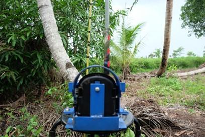
Another method that uses a time-lapsed camera was developed by the United Kingdom Center for Ecology and Hydrology. This low-cost method — about 500 to 650 pounds ($615 to $800) per unit — allows measuring small-scale peat elevation changes over time by using a commercially available camera, which is usually used to monitor wildlife activities. WRI Indonesia implemented this newly-introduced method in 2020. While the method has been written about in international journals and proceedings, becoming well accepted and recognized by academic communities, in Indonesia, the method still needs to be introduced to peatland-related authorities before there is wider implementation.Lastly, the peat subsidence issue must be brought to the awareness of public authorities and land users with a sense of urgency to emphasize its importance and make proper policies are designed.
They need to pay more attention to the triggers and subsidence rate in order to adapt to and mitigate the effects of peat subsidence. Efforts to do this are already taking place in Indonesia through a government-owned online data platform called the Peatland Restoration Information and Monitoring System.
Land users also need more information to manage the peatlands sustainably. Building partnership platforms to ensure they get the data, education, support and investment needed will encourage more urgent action. For example, WRI Indonesia led the People for Peat consortium to build an integrated database for peatland utilization management in Southeast Asian countries. The organizations also supported communities and companies through a platform that encourages a nurturing environment for sustainable investment and conducts various engagement events (such as regional peat symposiums, webinars and village events) to raise awareness and how to implement sustainable peatland management.
By knowing the impacts, with increased support and proper collaboration between various stakeholders, protecting peatlands around the world from peat subsidence is achievable. Most importantly, measuring the subsidence and current peatland conditions will ensure better peatland management.