

Featured WRI Experts:
Can Southeast Asia Achieve a Fire-Free El Niño Season? Part 1 - The Warning Signs Are Here

Gambar oleh
WRI Indonesia
Strength, destruction, a force of nature. These words have long defined Godzilla, the legendary monster from Japanese cinema. It is perhaps no surprise that the 2015-2016 El Niño, one of the strongest ever recorded, became widely known as the “Godzilla El Niño”. With forecasts pointing to a potentially strong El Niño in 2026, and forest and land fires already occurring across Indonesia and parts of Southeast Asia, immediate response must go hand in hand with preparations for potentially more severe conditions in the months ahead, given the risks to people’s health and livelihoods and the economic costs to affected countries.
Different Faces of El Niño’s Impact
The El Niño-Southern Oscillation (ENSO) or El Niño are characterized by surface warming of the tropical Pacific Ocean and weakening of equatorial trade winds that occur every 2-7 years. Such conditions are accompanied by changes in atmospheric and oceanic circulation, affecting global climate, marine and terrestrial ecosystems, fisheries and human activities.
El Niño redistributes rainfall globally by shifting the Walker circulation[1] and associated teleconnection patterns, producing drought in some regions and flooding in others. During an El Niño event, Peru, Ecuador and southeastern parts of South America receive heavy rainfall. In northern Brazil, drier conditions or even drought may result.
While El Niño can bring wetter conditions to part of South America, its effects are often very different in Southeast Asia. In Indonesia and neighboring countries, El Niño typically brings below-average rainfall and higher temperatures, creating drier conditions that increase the likelihood of forest and land fires (Figure 1). The risk can be further amplified when El Niño coincides with a positive Indian Ocean Dipole (IOD), which can further reduce rainfall across parts of Southeast Asia.
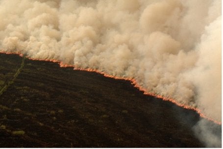
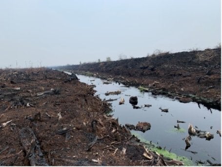
Forest and land fires trigger cascading impacts across ecosystems, economies, and human well-being. High-intensity fires destroy vegetation, degrade biodiversity, and release vast amounts of greenhouse gases, further accelerating climate change. At the same time, smoke from forest and land fires releases fine particulate matter (PM2.5) and other pollutants that degrade air quality. Further, recurrent forest and land fires disrupt local economies and impose billions of dollars in economic losses through damaged infrastructure, reduced agricultural production, and rising public health costs.
In Southeast Asia, these impacts are compounded by transboundary haze, where smoke from one country can affect millions of people across the region. During the peak of the fires between September and October 2015, PM2.5 pollution levels in Palangka Raya, Indonesia, soared to an astonishing figure of over 1,500 µg/m3.
Meanwhile, in Malaysia (specifically Kuching and Port Klang), concentrations reached 358 µg/m3 and 371 µg/m3, respectively. In Singapore, the recorded 24-h average concentration hit 132 µg/m3. Although PM2.5 levels in Malaysia and Singapore were lower due to the dispersion of pollutants during long-range transport, the recorded levels remained extremely high, more than eight times the level recommended by the WHO (15 µg/m3 for 24-h average). The contribution of transboundary pollutants to levels in Malaysia and Singapore is confirmed by studies tracing PM2.5 sources; one study found that in 2015, fires on the island of Sumatra accounted for 50% of fire-derived PM2.5 in Kuala Lumpur and 40% in Singapore.
Figure 2. Satellite view: Fire and Thermal Anomalies Driving Transboundary Haze Across Southeast Asia (credit: NASA, accessed through NASA Worldview)
In 2019, while the forest and landfire was relatively smaller (about 2.61 million hectares burned in 2015, compared with about 1.64 million hectares in 2019), air pollution remained significant. The peak of 2019 fires occurred in September, with average PM2.5 levels in Pekanbaru, Indonesia, reaching around 215 µg/m3 or categorized as “very unhealthy” in Indonesia’s air quality index. In Greater Kuala Lumpur (GKL), average PM2.5 levels ranged from 65 to 78 µg/m3, and in the southwestern area of Singapore, average concentrations during hazy days were around 63 µg/m3. Riau and Jambi provinces together accounted for about 97% of fire-derived PM2.5 levels in GKL.
2026 Super El Niño Is Underway
Since 1980, there have been three recorded Super El Niño events (another term for Godzilla El Niño), and the likelihood of the rare climatic event to happen this year is increasing and is projected to develop in the second half of 2026. In order for El Niño to hit “super” status, water temperatures in the Pacific Ocean need to be 2 degrees Celsius higher than normal over a three-month period, and the sign is already there. According to NOAA, the sea surface temperature in Niño3.4 region[2] for early August 2026 are the warmest ever recorded, indicating that the probability of Super El Niño to happen this year is getting stronger.
Fire Alerts Are Rising Across Southeast Asia
Elevated fire activity in Southeast Asia, exacerbated by El Niño, have already begun even before the event reaches its peak. This emerging risk is already reflected in the increasing number of satellite-detected fire alerts across this region. It provides an early indication for the region that may face heightened forest and land fire risk in the months ahead. Started with forest and land fires in Johor, which resulted in haze affecting Singapore during the first quarter of this year, early indicators of elevated fire risk are already visible in other parts of Southeast Asia.
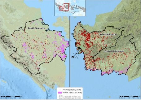
As an example of this analysis, combining the 2015-2016 burned-area footprint with current fire hotspot data shows a mixed pattern across South Sumatra, West Kalimantan, and Central Kalimantan (Figure 3). South Sumatra’s hotspots are scattered broadly, both inside and outside historically burned areas. Central Kalimantan shows hotspot dispersed across the western border, center, and south, with clearest overlap against the burned area along the southern coast, through much activity falls outside those historically burned areas. West Kalimantan has the densest hotspot activity of the three, concentrated in the north-central region, almost entirely outside any historically burned area, suggesting fire is emerging in landscapes with little prior burn history. Regardless of this variation, all three provinces show landscapes that remain persistently fire-prone, posing ongoing risks to surrounding communities and contributing to transboundary haze across Southeast Asia.
Wind direction determines where this smoke travels (Figure 4). During the current Southwest Monsoon, prevailing winds blow mainly from the southeast to the northwest, carrying smoke from South Sumatra, West Kalimantan, and Central Kalimantan toward Peninsular Malaysia, Singapore, Malaysian Borneo (Sarawak), and the Philippines. This is already playing out as of early-to-mid August 2026, Sarawak has repeatedly recorded unhealthy air quality with parts of Peninsular Malaysia also affected. Active hotspots have also been detected within Malaysia itself (Peninsular Malaysia and Sarawak), meaning some of the region’s haze stems from local ignition, not just smoke drifting from Sumatra and Kalimantan. This underscores that fire and haze risk this season is a region-wide issue, requiring coordinated monitoring through the peak of months of August-October.
Figure 4. Prevailing wind direction across Southeast Asia during 2026 fire season, illustrating potential pathways for transboundary haze
The warning signs are becoming increasingly difficult to ignore. With fire activity already emerging across parts of Southeast Asia and the potential for conditions to intensify during the coming dry season, the region now faces a critical window to turn early warnings into early actions. What can we learn from past efforts, and how can governments and non-governments actors including companies, communities, and other stakeholders turn those lessons into stronger preparedness? The Part II of this series explores these lessons and the actions needed to move toward a fire-free El Niño season.
[1] Walker circulation is a large-scale pattern of air movement across the tropical Pacific Ocean that strongly influences rainfall, clouds, and weather in Southeast Asia and the Pacific.
[2] The Niño 3.4 region is a central equatorial Pacific area used to monitor El Niño and La Niña events through sea surface temperature anomalies.
