
Belajar Cara Mencegah Kebakaran Gambut dari Taman Nasional U Minh Ha
Artikel ini untuk sementara hanya tersedia dalam Bahasa Inggris.
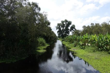
The U Minh Ha National Park is located in the southernmost province of Ca Mau, Vietnam, about 25 km from Ca Mau city. The total area of the park is 8,527.8 ha, which is divided into three functional sub-zones, namely: 1) Strictly protected sub-zone with an area of 2,593.7 ha; 2) Ecological restoration sub-zone with an area of 5190.5 ha; and 3) Administrative service sub-zone with an area of 743.6 ha. In U Minh Ha National Park, we can find two types of soil, peat, and clay.
The peatland area is around 31 percent of the park (2,654 ha), and the rest are clay areas (or non-peatland area). Since U Minh Ha National Park is a special-use forest area, there are no very specific differences in managing and protecting peatland and non-peatland areas.
However, the protection and management are carried out more carefully in the peatland area, according to Trần Quốc Khải, Head of the Science and International Cooperation Department in U Minh Ha National Park. The intensity of inspection and patrolling is also more prioritized in the peatland area because it has higher biodiversity. “We prioritize the fire prevention and fire fighting in the peatland area because if peat fires occur, it is very difficult to extinguish it because the fire not only burns the trees above ground but also burns the below ground,” Khải added.
The entire forest in U Minh Ha National Park is a special-use forest area and is strictly protected according to the regulations on the management of special-use forests in Vietnam's law. Therefore, no area of the U Minh Ha National Park is open to the community for agricultural use. Although it is located close to the communities, people are not allowed to enter in the entire forest of the national park without a permit.
U Minh Ha National Park has administrative boundaries with four communes of two districts, including U Minh district with two communes, Khanh An and Khanh Lam, and Tran Van Thoi district with two communes, Tran Hoi and Khanh Binh Tay Bac. The surrounding of U Minh Ha National Park is a buffer zone with a total area of about 25,000 ha. This area is managed by forestry companies or commune people's committees.
The livelihood of people around the buffer zone is mainly from agriculture, forestry, and fishery. The park prioritizes the communities who live in the buffer zone to help as workers. The communities get the opportunity to join some programs and activities, such as training for forest fire prevention and fire fighting, forest management and protection, and many other activities in the park. Khải mentioned that the U Minh Ha National Park allows the communities to utilize the water in the park for agricultural activities and also utilize the seeds from U Minh Ha National Park.
In U Minh Ha National Park, forest fires are triggered by various factors. Community interaction with the forest is just one of the causes of forest fires. Besides, forest fires can also be caused by natural disasters, such as lightning. However, forest fires do not often occur. The national park is really serious about preventing forest fires by conducting regular patrols and monitoring its territory continuously. In the last ten years, from 2011 to 2021, there was only one forest fire in 2016, with a total damaged area of 18.8 ha. The cause of the fire was determined as a lightning strike.
“In order to carry out the task of forest fire prevention and fire fighting, every year, at the beginning of the dry season, we develop a forest fire prevention and fire fighting plan, and at the same time, establish a commanding committee for forest fire prevention and fire fighting to handle other problems,” said Khải.
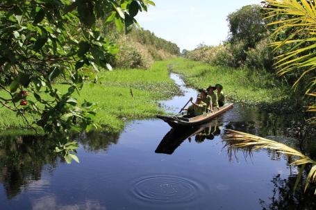
The forest management team always patrols and manages their assigned areas. The activities of patrol in the forest, forest management, and forest protection are conducted on both roads and waterways.
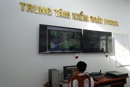
“Currently, U Minh Ha National park has 17 forest fire observation towers, which are used for observe, detect, and give warning if a forest fire occurs,” Khải added. Some of these towers were built in 2007. In the national park, two devices are set up to support forest fire warnings. These devices are hydrometeorological stations and forest fire warning cameras.
The major challenges that U Minh Ha National Park faces in forest fire prevention and fire fighting are lightning and the illegal sneaking of some villagers into the forest in the dry season.
To support forest fire prevention, Khải suggested that it is important to provide the staff with science-based equipment, to support their patrol activities in the effort of sustainably protecting and managing the forest. Equipment such as drone camera with thermal sensors can help preventing people for illegally entering the forest, as well as to support the biodiversity investigation. Also, the installation of a forest fire warning camera system with the forestry sector standard is also important.
Forest and peat fires do not occur frequently in U Minh Ha National Park, partly because of well-managed prevention activities. Every time a ranger sees smoke in the field, through the screen in the monitoring room, they are immediately checked. Residents of nearby villages are also prohibited from entering the park, which also prevents activities that could trigger forest degradation and fires. Although forest fires in the park are rare, the rangers must not be careless. A strict monitoring of human activities around the park needs to be carried out to preserve the forest and peat ecosystem.